Visited only by a small fraction of Icelandic sightseers, positioned off the well-worn Ring Road circuit, the Westfjords almost feel like an entirely separate country.
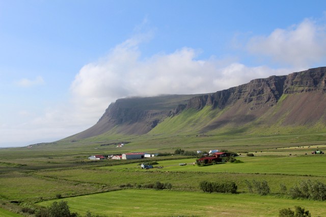
Here you’ll find an enormous collection of brooding mountains, dramatic peninsulas and azure fjords, joined to the rest of Iceland by just a slight sliver of land.
Sparsely populated, with tiny fishing villages and little towns clinging on to the habitable spaces between crashing ocean waves and imposing mountain ranges, a journey through the Westfjords encourages a gentler pace, as the natural grandeur takes hold and the desire to stop and savour will be undeniable.
You’ll need to go more slowly, to safely navigate the twisting fjordside roads and the steep, bumpy and rutted gravel mountain passes that link one little hamlet to the next.
There is another Ring Road here, of a very different nature to its big brother that circles the whole country, but a circuit nonetheless.
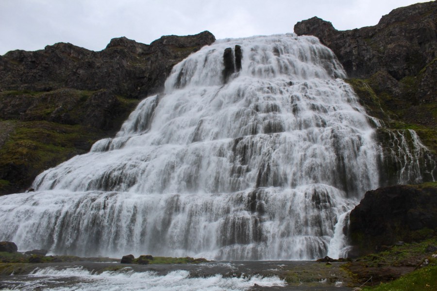
It’s possible to take in all of the southern and central peninsulas, either driving clockwise from Reykhólar or anti-clockwise from Hólmavík, with the epic falls of Dynjandi being the essential destination roughly halfway along the route from either starting point.
The northern route is a more comfortable drive, with well-paved roads tracing a mostly low-level coastal path up and down fingers of land to Súðavík and Ísafjörður, then through a 6km road tunnel towards Þingeyri and then to Dynjandi.
Beyond Dnyjandi, this route proceeds southwards either by a new road tunnel or a bumpy mountain pass drive over Hrafnseyrarheiði, on a road that is often only accessible in the summer and occasionally testing, even in good weather.
The southern route to Dynjandi is shorter, albeit paved for less of its length from Flókalundur.
Hornstrandir, the northern area of the Westfjords, is not particularly accessible by car and is a destination only for seriously determined hikers.
Approaching the Westfjords on Route 1 from Borgarnes, not long after Bifröst, the turn for Route 60 comes up on the left.

Búðardalur offers an opportunity for a pitstop with an interesting coffee shop adjacent to the ubiquitous N1 service station.


Not long after crossing the bridge over Gilsfjörður, there’s an option to detour on Route 607 to Reykhólar on Reykjanesfjall, where a pretty village clings onto the peninsula, with an option to wallow in seaweed baths available.
For those who remember the film “Close Encounters Of The Third Kind”, a mountain that rather resembles Devil’s Tower can be seen on the right hand side of the road at the junction with Route 607.

The road alternates between paved and gravel surfaces as it twists alongside Breiðafjörður until Flókalundur comes up, roughly halfway along the southern coastal path.

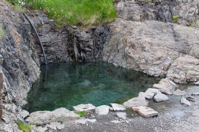
Flókalundur offers a good place to rest, stock up on supplies or camp, with gorgeous views towards Flatey and the Snæfellsnes peninsula. There’s a lovely hot pot too, right on the beach, called Hellulaug.
The ferry from Stykkishólmur puts in at nearby Brjánslækur.
A decision is required here – to head straight to Dynjandi by following Route 60 northwards, or to follow the coastal Route 62 towards Patreksfjörður, taking in the stunning bird cliffs of Látrabjarg and the enormous coloured sandy beaches of Rauðasandur.
This western diversion requires a minimum of several hours to fully savour, as a reward for the often uncomfortable sections of road that have to be traversed to reach both Látrabjarg and Rauðasandur.


Leaving Route 62, the unpaved 612 passes the wreck of the Garðar, a stranded old fishing boat, tracing a path along the northern side of this peninsula, offering views across the fjord to Patreksfjörður before it cuts inland past the fascinatingly unusual Minjasafn Egils Olafssonar Museum at Hnjótur.
Inside, there’s an amazing array of artefacts from the past, with all the ephemera associated with fishing and farming life on display, alongside the tale of an epic coastal rescue in the winter of 1947 of the crew from a wrecked British trawler.
The path then weaves its way past Breiðavík, where a hotel offers another option for refreshments, before pressing on to Látrabjarg and the westernmost points of Europe, Bjargtangar.
The gravel road hugs the sheer sides of the rising promontories, offering untrammelled views, but requiring close attention too.
Once reaching Látrabjarg, you can park up and then quickly ascend a well maintained path to the famed bird cliffs, where puffins, kittiwakes, fulmars, cormorants and many more species nest, squawk and breed in the summer months on skerries rising up to 400 metres above the surf, along a 14 kilometre stretch.
A small yellow sign near the lighthouse denotes the geographical significance of the site, being Europe’s western extremity.
Heading back on the 612, the coloured sands of the 10km wide Rauðasandur beach can be reached by taking another spur on Route 614, which will require a steep gravel road descent to the southern coast.
The French Cafe here offers a splendid opportunity to take in the panoramic views of this beach, as well as offering helpful advice to return a little way along the road and take the right hand fork to the Melanes campsite and the left hand section of Rauðasandur beach.
This approach offers both an easier and possibly drier walk to the beach, unaffected by the rising tides which can cut short a walk on the beach if it’s approached from the right hand segment of Rauðasandur.
Returning to the paved Route 62, Patreksfjörður is a good place to refuel and prepare for the next leg of the journey, taking in Tálknafjörður and Bíldudalur en route to Dynjandi.
Tálknafjörður is a small fishing village located on a short diversion off Route 63 (which takes over after Patreksfjörður) where a good camping site and swimming pool can be found.
Bíldudalur offers a first sight of the majestic Álftafjörður and is also home to one of the more amusing museums to be found here – the Icelandic Sea Monster Museum, where a number of highly unusual exhibits of “marine life” can be found. Folk culture is accompanied by multimedia displays, maps and videos to support the belief in lake and sea dwelling leviathans.
The road out of Bíldudalur quickly becomes very bumpy again as it rejoins Route 60 from the south and begins to head over yet another towering mountain pass.
This is a tough section of road and sufficient time needs to be factored into traversing this area, but there is ample reward on the other side, as Dynjandi begins to appear on the left hand side of the road, breathtakingly so.
A short road takes you into a car park at the foot of the 100-metre falls, enabling an easy ascent up a series of earthen steps right up to the main cascade itself.
It’s a stunning spectacle, even in a country stacked with waterfalls and other natural phenomena. Dynjandi certainly jostles for supremacy as the most photogenic of Iceland’s fosses.
Once you’ve absorbed enough of this wondrous location, there’s another testing mountain pass to come, as Hrafnseyrarheiði lies between Dynjandi and Þingeyri – another natural resting point with a campsite, a good hotel and a number of places to eat and drink.
But there is also a new 5.6km road tunnel (Dýrafjarðargöng) that connects Arnarfjörður and Dýrafjörður, which makes the journey between Dynjandi and Þingeyri much easier.
From this point on, the roads will be much smoother and easier to drive and journey times will become more predictable.
There is a three-way tunnel on Route 60 from Þingeyri and Flateyri onwards to Sudureyri and Ísafjörður, with recesses to allow oncoming traffic to take refuge. Northbound traffic has priority on the route to Ísafjörður.
Just before entering the tunnel, a charming cafe with wonderful views can be found on the road to Flateyri at Kaffi Sol.
Once through the tunnel system, the road sweeps down into Ísafjörður, the largest settlement in the Westfjords, set on a little spit of land and an obvious point to stop and take in supplies, while enjoying the delights of this stop on the ocean cruise liner routes. There are a great number of cafes, restaurants, bars set amongst the old houses and several companies offer excursions and guided trips.
The journey to Hólmavík from Ísafjörður on Route 61 is low, mostly flat and hugs the coastline, with sheer cliffs on the other side and is an easy drive.
The next potential stopping point is the Arctic Fox Centre in Súðavík, a dedicated research and study centre of Iceland’s only native land mammal. It’s very informative and there’s an opportunity to see a couple of these fascinating animals too.
Beyond Súðavík, the unbelievably gorgeous Álftafjordur stretches out with Valagil positioned as a fantastic place to stop and gaze around in wonder at the head of the fjord.
On the other side of Álftafjordur, the next promontory offers stunning vistas from the Kambsnes look out point, with uninterrupted views of the fjords and mountains of Südavíkurheppur, the island of Vigur, the Snæfjallströnd peninsula and the Drangajökull glacier.
On the next finger of land lies two attractions – the Hvitanes seal colony, which is very easily accessible from the road, and the Litlibaer Turf Museum, a restored historical turf house, offering coffee and inexpensive waffles.
Ogurnes is home to a puzzling Car Cemetery, where dozens of wrecked and abandoned vehicles are lined up in a field.
Beyond lies Mjóifjörður, a narrower fjord which allows for a bridge to offer a short cut to the next peninsula, although a 12km gravel road on Route 633 also presents the option of a fine restaurant and multiple accommodation options in the peaceful and picturesque Heydalur valley.
The last fjord heading eastbound on the northern coast is Ísafjörður, with tiny Reykjanes on the western side providing hot pots and a campsite and the spooky abandoned house at Arngerðareyri lurking on the eastern side, left bereft and silent for more than 40 years.
Next on this route is another “up and over” across Steingrímsfjarðarheiði, arriving finally at Hólmavík, a charming fishing village and home to another unusual exhibition, the Museum of Sorcery and Witchcraft, where dark tales of the spellbinding Icelandic past are brought to life with a series of alarming installations and artefacts. There’s a good restaurant here too.
From Hólmavík, Route 61 loops back to Gilsfjörður, Borgarnes and Reykjavík, while Route 68 goes towards Akureyri along faithful Route 1.
